


170811 j4 hostias brenod

azipat
Gebruiker
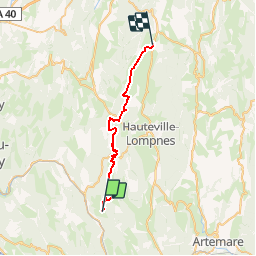

Lengte
28 km

Max. hoogte
986 m

Positief hoogteverschil
816 m
Km-Effort
38 km

Min. hoogte
452 m

Negatief hoogteverschil
794 m
Boucle
Neen
Datum van aanmaak :
2017-08-11 00:00:00.0
Laatste wijziging :
2017-08-11 00:00:00.0
4h40
Moeilijkheid : Medium

Gratisgps-wandelapplicatie
 SityTrail
IGN / Geografische instituten
SityTrail Plus
De wereld gaat voor u open
Over ons
Tocht Paard van 28 km beschikbaar op Auvergne-Rhône-Alpes, Ain, Plateau d'Hauteville. Deze tocht wordt voorgesteld door azipat.
Plaatsbepaling
Land:
France
Regio :
Auvergne-Rhône-Alpes
Departement/Provincie :
Ain
Gemeente :
Plateau d'Hauteville
Locatie:
Unknown
Vertrek:(Dec)
Vertrek:(UTM)
696611 ; 5086318 (31T) N.
Opmerkingen